
Severe Cyclonic Storm Montha has begun making landfall along the Andhra Pradesh coast near Kakinada on October 28, 2025, bringing winds of 90-100 kmph with gusts reaching 110 kmph. The India Meteorological Department (IMD) confirmed the landfall process as thousands of residents take shelter and authorities implement emergency protocols across coastal regions.
With over 38,000 people evacuated, 60+ trains cancelled, and all flights grounded at major airports, Cyclone Montha represents one of the most significant weather events to impact India’s eastern coast this year.
Table of Contents
Cyclone Montha: Critical Information at a Glance
| Category | Details |
|---|---|
| Landfall Location | Between Machilipatnam and Kalingapatnam, near Kakinada |
| Landfall Time | Evening/Night of October 28, 2025 |
| Wind Speed | 90-100 kmph, gusting to 110 kmph |
| Classification | Severe Cyclonic Storm (SCS) |
| States Affected | Andhra Pradesh, Odisha, Telangana, Tamil Nadu, Chhattisgarh |
| People Evacuated | 38,000+ (Andhra Pradesh), 11,396+ (Odisha) |
| Flights Cancelled | 70+ across affected airports |
| Trains Cancelled | 60+ services suspended |
| Relief Centers | 2,000+ operational in Odisha alone |
Massive Evacuation and Emergency Response
Authorities have mounted one of the largest disaster preparedness operations in recent memory. Odisha Chief Minister Mohan Charan Majhi confirmed that over 2,048 relief shelters have been established across eight southern districts, currently housing 11,396 evacuees with capacity for many more.
In Andhra Pradesh, Chief Minister Chandrababu Naidu has been personally monitoring the situation from the Real-Time Governance System (RTGS) control room, coordinating with Deputy CM Pawan Kalyan to ensure comprehensive coverage.
Kakinada MP Uday Srinivas Tangella emphasized the scale of preparations: “Over 800 shelters are operational with full facilities. We’ve deployed 1,000 electricians for power restoration, 140 trained swimmers with boats for rescue operations, and pregnant women have been shifted to hospitals.”
The National Disaster Response Force (NDRF) has positioned 25 specialized teams across vulnerable coastal districts in Andhra Pradesh, Odisha, Tamil Nadu, Chhattisgarh, and Puducherry, with 20 additional teams on standby.
For more disaster preparedness tips and emergency updates, visit TechnoSports’ News Section.
Transportation Comes to a Standstill
Air Travel Disrupted: GMR Airports confirmed the cancellation of 37 flights between Telangana’s Shamshabad and Andhra’s Vijayawada, Visakhapatnam, and Rajahmundry airports. At Visakhapatnam Airport alone, all 32 scheduled flights were cancelled, while Vijayawada saw 16 cancellations and Tirupati grounded four flights.
Airport Director N. Purushottam stated: “We average 30 to 32 flight movements daily. Today, all stand cancelled for passenger safety.”
Rail Services Halted: Indian Railways has suspended over 60 train services passing through affected regions as a precautionary measure. Union Minister Ashwini Vaishnaw personally reviewed railway preparedness, instructing officials to implement comprehensive safety protocols along the East Coast.
Nine Visakhapatnam-bound trains and multiple services connecting Bhubaneswar have been cancelled, with operations to resume only after weather conditions stabilize.
Port Alerts and Coastal Safety Measures
The India Meteorological Department issued varying warning levels across coastal ports:
- Red Warning Signal No. 10: Kakinada Port (highest alert)
- Warning Signal No. 9: Visakhapatnam, Gangavaram, Machilipatnam ports
- Local Warning Signal No. 4: Chennai, Ennore, Kattupalli ports (Tamil Nadu)
- Distant Warning Signal No. 2: Cuddalore, Nagapattinam, Puducherry, Karaikal
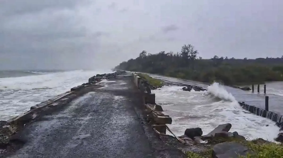
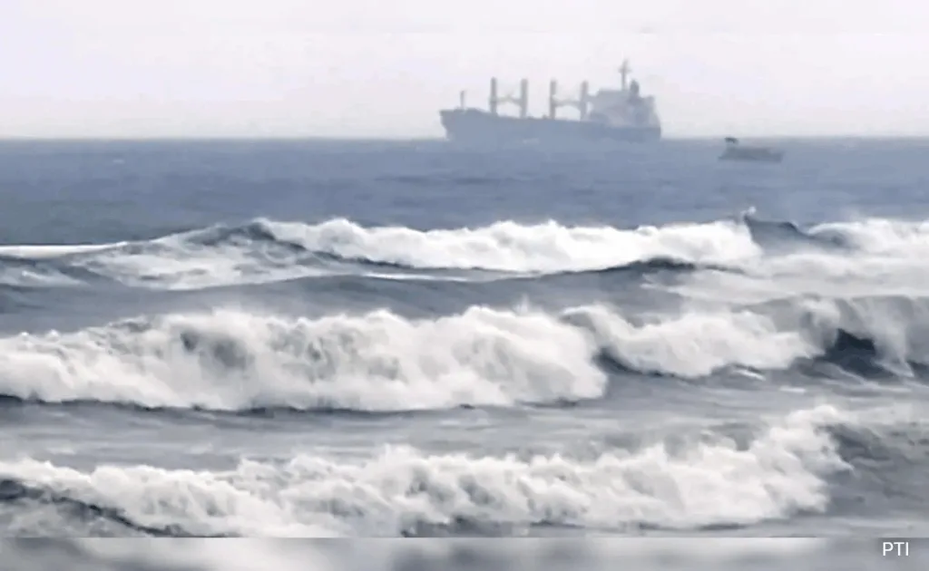
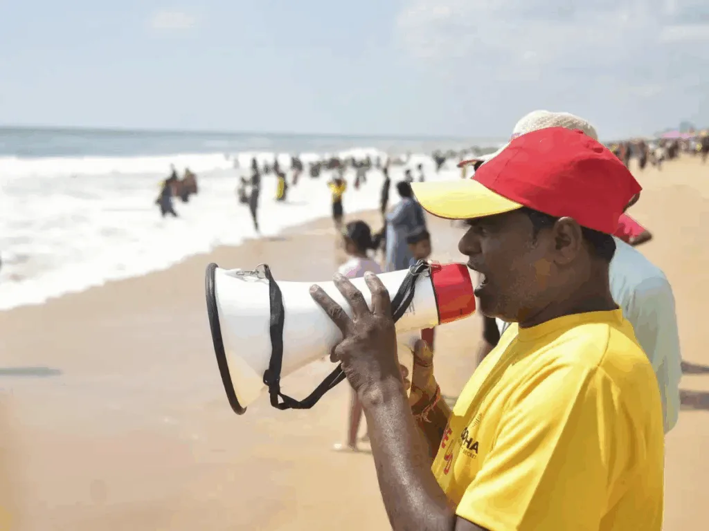
Authorities have barred people from entering the sea across Odisha and Andhra Pradesh coastlines, with coastal police and disaster response teams patrolling shorelines to prevent accidents.
Fishermen in Chennai’s Pattinapakkam beach have secured their boats, covered engines, and stored nets safely as turbulent waves crash against Marina beach
.
Rainfall and Weather Impact
Parts of Coastal Andhra Pradesh and Yanam have recorded extremely heavy rainfall exceeding 21 cm in the past 24 hours. Nellore District has experienced continuous rainfall for 36 hours, with some mandals recording 7-8 cm.
The IMD has issued heavy rainfall warnings extending beyond the immediate landfall zone to Rayalaseema, Kerala, Chhattisgarh, East Madhya Pradesh, Maharashtra, and Tamil Nadu, where precipitation ranges between 7-11 cm.
Heavy rains in Visakhapatnam triggered a wall collapse, though no casualties were reported. Authorities cleared debris and are monitoring vulnerable structures across the region.
Stay updated on weather developments through our live news coverage at TechnoSports.
Ground-Level Preparedness Measures
Odisha’s Comprehensive Response: More than 5,400 residents from hilly regions vulnerable to landslides have been moved to cyclone shelters with proper food, water, and medical facilities.
Power and Communication: Andhra Pradesh has deployed 1,000 electricians to ensure rapid power restoration post-cyclone, while communication systems remain operational for coordination between relief agencies.
Medical Preparedness: Pregnant women in vulnerable coastal areas have been shifted to hospitals, ensuring access to emergency medical care if needed during the storm.
Community Involvement: Political party workers are assisting in evacuations and shelter management, demonstrating cross-party cooperation during emergencies.
Ganjam administration in Odisha has urged residents to avoid coastal areas and move to designated relief shelters, emphasizing that prevention is better than cure.
Regional Impact Beyond Andhra Pradesh
While Kakinada bears the brunt of the cyclone, neighboring states face significant weather disturbances:
West Bengal: A blue alert has been issued in Purulia district as overcast skies signal Montha’s extended influence.
Tamil Nadu: Despite being south of the landfall zone, Chennai experiences moderate rainfall and turbulent seas at Marina Beach.
Odisha: Chilika Lake near Kalijai Temple shows choppy waters and fierce winds, prompting authorities to restrict water activities.
The cyclone’s extensive reach demonstrates how severe weather systems affect regions far beyond the immediate landfall area.
What Happens Next?
The IMD expects Cyclone Montha to maintain severe cyclonic storm intensity during landfall before gradually weakening as it moves inland. Heavy rainfall is likely to persist for another 12-14 hours across affected regions.
Authorities will begin damage assessment and relief distribution once wind speeds reduce to safe levels. Power restoration teams, medical units, and supply chains stand ready to mobilize immediately after the storm passes.
The focus now shifts to minimizing casualties through strict adherence to safety protocols and efficient evacuation procedures—areas where both Odisha and Andhra Pradesh have built considerable expertise following previous cyclonic events.
For continuous updates on Cyclone Montha and other breaking news, follow TechnoSports.
For real-time weather updates, disaster preparedness guides, and emergency news coverage, visit TechnoSports and bookmark our breaking news section.
Frequently Asked Questions
Q: Why is Cyclone Montha considered particularly dangerous?
Cyclone Montha has intensified into a Severe Cyclonic Storm (SCS) with wind speeds of 90-100 kmph, gusting to 110 kmph—sufficient to cause significant structural damage, uproot trees, disrupt power lines, and create life-threatening storm surges. The landfall near Kakinada, a densely populated port city with 4 lakh residents, increases vulnerability. Additionally, Montha’s wide reach affects multiple states simultaneously, stretching emergency resources. The timing during October’s northeast monsoon season compounds rainfall risks, potentially causing flooding and landslides. The IMD’s red alert at Kakinada Port reflects the highest warning level, indicating imminent danger to life and property in the immediate landfall zone.
Q: How should residents in affected areas stay safe during Cyclone Montha?
Residents should immediately move to designated cyclone shelters if living in low-lying coastal areas or vulnerable structures. Stay indoors away from windows, secure loose objects that could become projectiles, and stockpile at least 3 days’ worth of drinking water, non-perishable food, medicines, and essential supplies. Keep mobile phones charged with power banks ready, and monitor official IMD bulletins via radio or SMS. Avoid coastal areas, beaches, and flooded roads—even shallow water can hide dangerous debris or currents. Do not venture out during the “eye of the storm” (temporary calm period), as fierce winds return afterward. Follow evacuation orders immediately, as authorities prioritize saving lives over property. Post-storm, avoid damaged buildings, fallen power lines, and contaminated water sources until declared safe.